Trees Don't Spin: Plants respond to the big picture

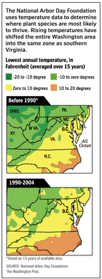
The Washington Post provides a dramatic illustration for what I've been saying about climate change being imperceptible from one year to the next, but indisputable when viewed over recent decades. The source is the National Arbor Day Foundation, hardly a hotbed of half-baked hyperbole:
A warming climate in the Washington area is beginning to affect the area's trees, with cold-loving species finding the weather less welcoming and southern transplants thriving, according to findings released yesterday by the National Arbor Day Foundation.
In a revised map of "hardiness zones" -- bands of similar temperatures where similar trees are likely to grow in winter -- the foundation reclassified the entire Washington area in the same zone as parts of North Carolina and Texas. In 1990, the region was on the border of northern and southern growing zones, but a foundation official said that has changed after 15 years of balmy winter weather.
The foundation's findings provide a window into the local effects of climate change, scaled down to lawn level. Colorado blue spruce and hemlock, at home in the cold, might have a harder time. Crape myrtles and camellias will have it easier.
"You could say D.C. is the new North Carolina," said Bill McLaughlin, a curator at the U.S. Botanic Garden on the Mall.
The Washington area's warming trend is one of many that the foundation detailed across the country as it presented its updated map.
In parts of Michigan, for example, the climate has warmed enough to accommodate southern magnolia trees, said Arbor Day Foundation spokesman Woodrow L. Nelson. Arizona cypress, another southerly species, also suddenly seems a better fit for some sections of the Northeast, he said.
"I mean, who would have thought that an Arizona cypress would be a choice for someone in New Jersey?" Nelson said.
The map divides the continental United States into nine zones, from Zone 2 near the Canadian border to Zone 10 at the tip of Florida. (Zone 1 is found only in Alaska's frigid interior, Zone 11 only in tropical Hawaii.) The zones were mapped by examining local weather data and averaging the lowest temperature recorded in the 15 previous winters.
The last time the U.S. Department of Agriculture presented such a map, in 1990, the Washington area sat on the boundary of two of these bands. Part was in Zone 6, an area from Massachusetts to Kansas where the lows hovered between zero and 10 degrees below. The other part was in Zone 7, stretching across the upper South, where temperatures were between zero and 10 degrees.
But in the foundation's revised map, the southern climate zone has swallowed the remainder of the area, taking in parts of the District, Montgomery County, and western suburbs in Virginia and Maryland. All of Zone 7 has shifted north. The zone now takes in most of Tennessee and Virginia as well as parts of North Carolina, Arkansas and Oklahoma.


0 Comments:
Post a Comment
<< Home